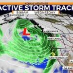

PORTLAND, Ore. (KOIN) — Stormy weather is set to return to northwest Oregon and southwest Washington starting Tuesday night, bringing a mix of rain, strong winds, and even the possibility of severe thunderstorms through midweek. A strong low-pressure system is expected to move inland, creating unstable weather conditions across the region.
Tuesday Night
Light rain showers will begin in the Portland metro area after about 3 p.m. Tuesday, gradually increasing in intensity. Along the Oregon Coast, rain could be heavy at times as powerful rain bands move through. Winds will also pick up through the evening, with gusts up to 35 mph expected in Portland.
Despite the strong gusts, widespread power outages are not expected. However, residents should secure loose outdoor items and be prepared for minor disruptions.
Wednesday
Wednesday will bring the most active and potentially hazardous weather. The Willamette Valley and coastal areas will experience continuing rain and wind, while scattered thunderstorms are expected to develop throughout the day.
These storms could produce brief heavy downpours, lightning, gusty winds, and small hail. A few may even turn marginally severe, especially near the I-5 corridor and the Oregon Coast.
Also Read
According to the National Weather Service, there is a 2% to 4% chance that any severe storm could generate a waterspout or weak tornado. Additionally, large hail up to 1 inch in diameter and wind gusts as strong as 60 mph are possible in isolated areas.
In Portland, winds will remain breezy, with gusts peaking around 30 to 40 mph. Along the coast, wind speeds could reach up to 50 mph, potentially causing isolated power outages and minor damage.
Coastal communities should also be on alert for minor flooding during high tide periods through midweek. Drivers traveling along Highway 101 in Clatsop and Tillamook counties should use extra caution due to the risk of standing water and sneaker waves. These unpredictable waves can surge farther up the beach than expected, carrying debris or even sweeping small animals or children into the water.
Thursday
Unsettled weather will continue into Thursday, though conditions will gradually begin to ease. Expect breezy winds up to 25 mph in the Portland area and frequent rain showers through the afternoon. While Thursday won’t be as stormy as Wednesday, wet roads and gusty conditions may still affect commutes and outdoor plans.
Looking Ahead
By Friday, the region will finally get a break from the stormy pattern. Forecasters expect drier and calmer weather to return, setting the stage for a more stable weekend.
The KOIN 6 Weather Team advises residents to stay alert for changing conditions, especially on Wednesday, when the threat of severe weather is highest. Keeping an eye on updated forecasts, securing outdoor items, and exercising caution near coastal areas can help ensure safety during this week’s stormy stretch.