
In a groundbreaking discovery that combines cutting-edge technology with maritime history, a man has uncovered a 138-year-old shipwreck in Lake Michigan using satellite images. This find has not only amazed historians and archaeologists but also reignited public interest in the maritime heritage of the Great Lakes. Lake Michigan, renowned for its treacherous waters and long history of shipwrecks, has once again revealed a powerful reminder of the dangers sailors once faced.
This discovery illustrates how advanced remote sensing tools and satellite imagery are transforming maritime archaeology. The combination of human curiosity and space-age technology has brought to light a story hidden beneath the waves for over a century.
Background: The Legacy of Shipwrecks in Lake Michigan
Lake Michigan is one of North America’s most storied inland seas, with a maritime history stretching back to the 17th century. The lake is often called a “ship cemetery” due to the sheer number of wrecks lying on its floor. Historians estimate that more than 1,500 shipwrecks have occurred in the Great Lakes, with Lake Michigan holding hundreds of them.
Also Read
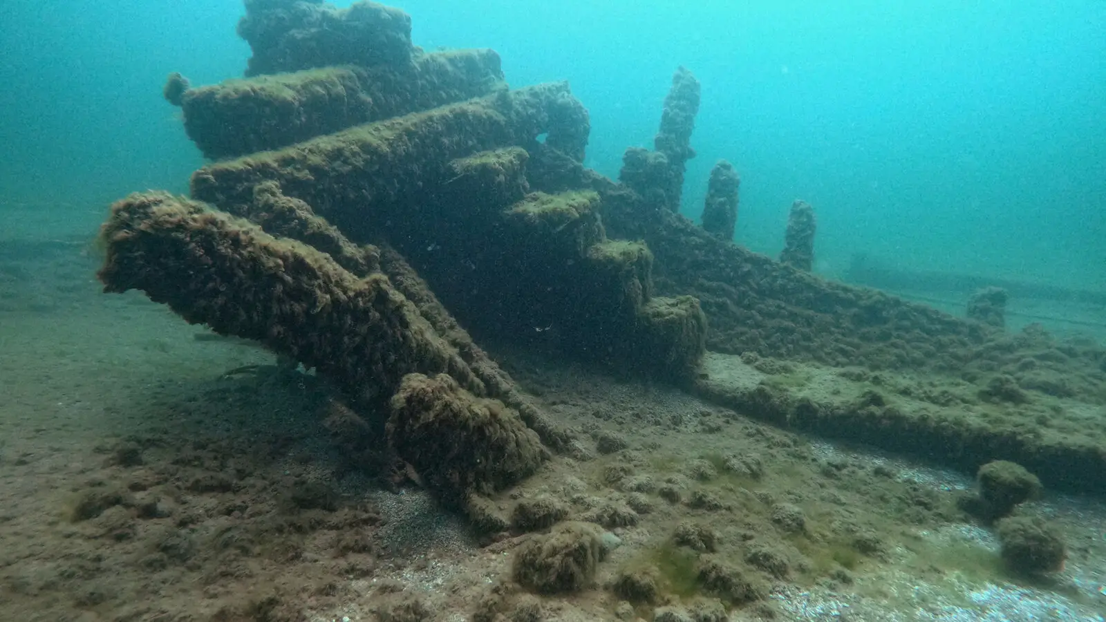
The newly discovered wreck is believed to date back 138 years, placing its sinking sometime in the late 19th century, an era when wooden schooners and steamships dominated commerce. This was a period marked by rapid industrial growth in the United States, with the Great Lakes providing a crucial shipping corridor for goods such as lumber, grain, and iron ore.
The Discovery: Satellite Images Reveal the Unseen
The breakthrough came when a technology hobbyist and maritime enthusiast meticulously examined publicly available high-resolution satellite images of Lake Michigan. While reviewing the images, he noticed faint outlines that resembled the structure of a ship.
By carefully comparing the satellite patterns with historical records of shipwrecks in the region, he realised that the outlines matched the dimensions of an unrecorded 19th-century vessel. Subsequent verification by underwater imaging specialists confirmed the find.
This unusual method of discovery highlights a growing trend in which satellite technology is being used for archaeological purposes. Traditionally, divers and sonar scans were the prime methods of exploration, but satellite imaging now provides a broader, non-invasive, and cost-efficient option.
The Ship’s History: Piecing Together the Past
Historical archives suggest that the wreck discovered may be the remains of a commercial schooner that sank during one of Lake Michigan’s infamous storms in the 1880s. At that time, ships made frequent journeys carrying timber and grain across the lake, often encountering severe weather with little warning or advanced equipment to help the crew.
Researchers are still analyzing the dimensions, wood composition, and design details to match it with known lost ships from that period. Although the ship’s identity has not been conclusively confirmed, maritime experts believe it belongs to a vessel that mysteriously vanished around 1887, during a particularly violent autumn storm.
Why Lake Michigan Holds So Many Shipwrecks
Lake Michigan’s geography makes it particularly prone to shipwrecks. Its vast size and frequently unpredictable weather create hazardous conditions for vessels.
The late 19th century experienced intense commercial activity, and ships often sailed overcrowded with cargo. Coupled with storms, thick fog, and navigation limitations of the time, mishaps were common. Ice also posed seasonal dangers, causing numerous accidents.
Significance of the Discovery
The discovery of this shipwreck has immense cultural, historical, and scientific importance:
-
Historical preservation: The wreck provides a glimpse into 19th-century boat craftsmanship, trade practices, and life on the Great Lakes.
-
Tourism and education: Such discoveries often spark local tourism as divers, researchers, and history enthusiasts flock to learn about them.
-
Technological innovation: The use of satellite images sets a precedent for future underwater archaeological breakthroughs.
Archaeologists believe this wreck could be a “time capsule,” potentially containing preserved items—tools, personal belongings, or trade goods—that can reveal more about life in the period.
Technology and Archaeology: A New Era
The use of satellite technology for shipwreck discovery is a promising innovation in maritime archaeology. The high clarity of today’s satellite cameras allows researchers to identify subtle disturbances on water surfaces and faint visual cues of structures beneath shallow waters.
This marks the start of a more accessible phase of exploration. Whereas sonar requires specialized ships and diving requires risky underwater operations, satellite scans can be conducted remotely, reducing costs and hazards.
Impact on Local Communities
The discovery has stirred excitement among local Michigan communities, especially historians, divers, and cultural organisations. Plans are already being discussed for:
-
Creating a 3D digital reconstruction of the wreck for museums.
-
Developing educational programs about maritime heritage.
-
Safeguarding the wreck site as part of underwater cultural preservation efforts.
If opened for controlled exploration, the site could contribute to Michigan’s growing heritage tourism sector, which already benefits from the Great Lakes Shipwreck Tour industry.
A Timeline of Maritime Losses in Lake Michigan
To put this discovery in context, below is a timeline of significant shipwrecks in the lake’s history:
| Year | Ship Name | Type | Cause of Sinking | Location |
|---|---|---|---|---|
| 1860 | Lady Elgin | Sidewheel steamer | Collision with schooner Augusta | Near Winnetka, Illinois |
| 1883 | Prairie State | Schooner | Storm | Mid-lake |
| 1887 | Unidentified schooner | Schooner | Violent storm | Likely Northern Lake Michigan |
| 1913 | Henry B. Smith | Freighter | Great Storm of 1913 | Lake Superior, connected route |
| 1929 | SS Senator | Steamer | Collision with bulk carrier | Near Port Washington, Wisconsin |
This new find potentially fills a gap in the maritime records of the 1880s.
Preservation Challenges
Shipwreck preservation is a delicate task. Wooden structures, while remarkably resilient underwater, face decay once disturbed. Archaeologists work cautiously to document, photograph, and digitally map the wreck without causing damage.
There is a constant tension between preservation, tourism, and natural degradation. Many historic wrecks have been looted, reinforcing the need for strong protective laws and responsible cultural management.
Future Prospects: What Comes Next?
Experts believe that this discovery is only the beginning. Satellite imaging, combined with artificial intelligence, could lead to identifying many more shipwrecks throughout the Great Lakes and beyond. This also sets a precedent for using similar technology to explore other historically significant bodies of water worldwide.
As for the wreck in Lake Michigan, researchers hope to:
-
Officially identify the ship through cross-referencing archives.
-
Conduct underwater robotic surveys to create high-fidelity 3D models.
-
Preserve it as part of Michigan’s rich maritime heritage sites.
Conclusion: Where History Meets Technology
The discovery of a 138-year-old shipwreck in Lake Michigan highlights the perfect intersection of technological progress and historical curiosity. What was once hidden beneath the depths of the lake has come back to life through the lens of satellites orbiting the Earth.
This finding is more than just the recovery of a sunken vessel; it symbolises human persistence in uncovering the past, ensuring that the stories of lost sailors and their journeys are never forgotten.
FAQs
1. How was the 138-year-old shipwreck discovered in Lake Michigan?
It was discovered through high-resolution satellite images, where a man noticed the outlines of a sunken vessel. Verification came from underwater imaging experts.
2. Why is Lake Michigan known for shipwrecks?
Because of its massive size, unpredictable storms, and high commercial traffic in the 19th and early 20th centuries, hundreds of vessels sank in the lake.
3. Can divers explore this new shipwreck?
The site is still under study, and authorities may restrict access to protect it. Future tours may be offered in a controlled and preserved manner.
4. Why is this shipwreck historically important?
It offers insights into 19th-century maritime trade, shipbuilding techniques, and the life of sailors who worked the Great Lakes.
5. Will satellite technology be used for future shipwreck discoveries?
Yes, satellite imaging combined with AI tools has huge potential for uncovering hidden wrecks across the world’s lakes, seas, and oceans.